Nitrogen rate recommendation to satisfy regulatory demand
Our Nitrogen recommendation services optimize fertilizer use for regenerative farming, maximizing yield and environmental stewardship. We foster trusted relationships with farmers by providing tailored, data-driven insights
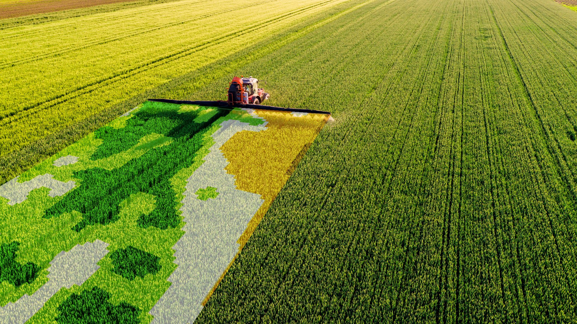
Nitrogen recommendation (Rx)
Plant-need-based fertilization insights for data-driven decision-making

Pre-Season Nitrogen Rx
Ideal for managers advising farmers who apply a single fertilizer application at the start of the season, like corn growers in Europe. Our Pre-Season nitrogen Rx enables precise fertilisation application from the start, maximising crop development and yield while avoiding oversupply.

In-Season Nitrogen Rx
Tailored for managers guiding farmers using split nitrogen applications, common among European wheat growers. This eco-conscious approach reduces nitrogen usage while maintaining yield and quality, aligning with regulations and fostering regenerative agricultural practices.

Regional N Rx
Our Quick Checks tool helps managers identify nitrogen optimization opportunities in their areas. Our regional N Rx offer swift assessments, enabling you to identify potential savings in your farmers' fields. Facilitate your farmers' transition to sustainable agricultural practices effortlessly.
Additional maps

Discover our simplified precision farming solutions with our Soil Productivity map, your essential tool for all Variable Rate (VR) applications
Identify management zones with varying productivity levels.
Ideal for seeding, pre-emergence fertilizing, liming, or slurry application.
Gain insights into your field's potential and optimize zone-specific soil sampling.

Additionally, for your weekly field performance updates, subscribe to our Biomass Map
Track site-specific crop Vital Biomass development over time.
Perfect for plant protection or growth regulator applications, and harvest timing decisions.
Streamline field scouting efforts by pinpointing underperforming regions from a distance.
Experience our solutions’ features in APP or API
Automatic field boundary detection
Experience effortless field installation. Our solution detects fields with a simple click on the map. Alternatively, you have the flexibility to draw or upload your own field boundaries.
Revise zone number and dose rates
Take control of your farming decisions. Easily revise the recommended zone number and dose rates according to your preferences and expertise.

Export application map as a terminal file
Seamlessly download your revised application maps in ISOXML, Shapefile, or Rx format. Share them via email directly from our solution, and obtain PDF files for comprehensive documentation.

Create an application map using any map
Empower your flexibility. Utilize any preferred map as the basis for generating your application maps. We guide the most suitable maps for specific applications while allowing you to make your own choices.

Batch application map generation
Efficiency at its best. Generate multiple application maps in one go. Whether it's a Corn Seeding map for 50 fields or any other scenario, specify the rate, zone number, and variation, and receive all application files conveniently via email.

Scouting point generation
Enhance field scouting with precision. Identify spots for scouting based on field variability. Our solution generates scouting coordinates based on the number of locations you provide (1-10), ensuring thorough field monitoring.

“ We leverage Spacenus’ Soil Productivity Map in our app, and it is one of the fastest-growing apps in the market, helping farmers earn at least 20 euros more per hectare. Thanks to this, we've grown to 18,000 users worldwide—a real win for farmers and consultants. ”
Tailored growth strategies: Free consultation
Unlock tailored growth strategies for your unique business needs. Whether you're navigating challenges or seeking specialized solutions, our free consultation offers personalized guidance. Let us steer your business towards success. Schedule your free consultation today.

Precision farming FAQ
If you want to learn more, here are some related information:
-
DescriptionYield and fertilizer use both are optimized by Spacenus. In addition to attempting to reach 85% Nitrogen Use Efficiency (NUE), it seeks to increase yield (e.g., optimized plant nutrition reduces the lodging risk) text goes here
-
Our precision farming solutions provide a tractor-readable file (e.g., John Deere format, ISOXML format or Shapefile etc.) format for a variable-rate recommendation map for a field in kg/ha unit. The recommendation can also be compressed such that the user receives a flat-rate recommendation for the whole field and can be sent via an excel file table.
-
Our recommendation models are crop-specific and currently, our solution supports wheat, Barley, Rapeseed and Corn crop. The models are not region-specific and it should work everywhere. However, we have only evaluated our models in Europe and the United States.
-
We require information on the field boundary and the crop type for the current season in order to make in-season recommendations. We would also want previous crop type information in order to offer the pre-season recommendation. However, there is no need for yield data, soil test data, or any other kind of data.
-
We only make use of Sentinel-2 satellite data, which offers details on plant development, actual nitrogen uptake by plants, and environmental factors including soil/crop moisture levels. Our system offers fertilizer recommendations by fusing these different sources of information.
-
Our APIs and web app ANA use nearly all Sentiniel-2 bands since various bands provide different sorts of information. NIR, for example, offers information on the size of the plants. As plants get larger and the NIR becomes saturated, RegEdge bands become effective for extracting plant growth information because they can penetrate through the plant canopy. Furthermore, several RedEdge bands are used to derive information on actual nitrogen uptake. Furthermore, the shortwave infrared (SWIR) band are used to determine the moisture status of plants and soil.
-
We cultivated plants in a controlled setting and conducted plant tissue tests to obtain around 30,000 data points. These data points were then used to calibrate satellite images such that plant dry matter in t/ha and actual nitrogen absorption in kg/ha could be measured. By combining these two parameters we provide absolute N recommendations.
-
We do not check the soil or the weather; instead, it employs plants as a sensor. The notion is that the plant reflects what occurs in the soil and with the weather. In order to evaluate the nutrient requirement, we first examine the plant development, which is the outcome of the interaction between the plant, soil, and water. Smaller plant growth needs less fertilizer. On the other side, we also take a look at how much nitrogen the plant already has taken up, which shows the amount of accessible nutrients for the plant in the soil. We can then create a precise nutrient recombination by combining plant growth and nutrient uptake. However, using the soil type information enhances the recommendation without a doubt, but the high resolution soil data is not available for every field. The recommendation would also benefit from taking weather data into account, but only if we had access to an accurate 15-day forecast of precipitation, which is likewise not possible at the field size. In order to serve farmers efficiently and affordably while relieving them of some of the strain associated with data requirements, we do not currently take those into consideration.
-
Soil test data for nutrients are valuable to our model since they let us fine-tune the recommendation. However, in our experience, this is beneficial when there is a suspicion that there is leftover nitrogen in the soil from a prior year otherwise we also can skip that. Then again, when a farmer transitions to precision farming for the first time, the results of the soil test may be useful once. After using our recommendations for a few seasons, it is possible to estimate the availability of soil nutrients; hence, additional soil tests are not necessary for N application decisions.
-
Our models take into account soil N mineralization as well as unused N from previous years. In the case of in-season recommendations, if there is unutilized N in the soil, the N shortage value will be lower, lowering the recommendation automatically. This is also taken into account in the case of pre-season recommendations, as ANA makes recommendations based on field-specific and crop-specific N utilization capability based on historical observations. However, we are aware that there is still room for improvement, but because farmers in general overfertilize their fields and we are aiming for 85% NUE rather than higher value, our recommendation works well.
-
This is a very good question. This will have almost zero impact in-case the farmers are utilizing in-season recommendation as the in-season recommendations are based on N-shortage observation – the lower the shortage (the plant has accessible nutrient in the soil) the lower the recommendation. But in case of pre-season recommendation, an average year, such as 2022, will have little impact on the model's pre-season prediction. Extreme years, such as 2017 (wet) and 2018 (dry), will have a greater impact on the recommendation as it learns more about the interactions between soil, water, and nutrient supply. However, because our model uses data from multiple historical years, these influences are smoothed out and our recommendation is rather conservative (not too high, not too low). According to our piloting experience during the first year piloting, the main impact would be that the user would become aware of a N rate that their field and plant require and can utilize. As ANA gets used year after year, the recommendation becomes more effective as farmers practice and our recommendation will gets closer and closer. As a result, I anticipate that the influences of our model will have a greater impact in 3/5 years.
-
Yes, you can. If you want to keep things simple while still being productive, you may use our Soil Productivity Map for all your field applications, including VR liming and slurry. The fundamental idea is to utilize field-specific soil productivity knowledge to reduce input costs while increasing yield. This map shows the locations of favorable and unfavorable growing conditions in a field (a result of integrating soil, terrain, and water availability, among other factors). You may choose a field-average application rate (what you generally use and consider decreasing it by 5 - 10% for best results), and our map will calculate zone-specific rates depending on the field potential, given in percentage.
-
Approximately 16,000 users used our Soil Productivity Map-based application maps between 2018 and 2021, and the feedback was very positive. The fertilizer recommendation maps were validated with 60 farmers over three years (2019–2021) under the framework of an ESA pilot project, and they reported an average return of roughly 35 euros per hectare.
-
There are three maps. You should use the Nitrogen Shortage Map to fertilize your field; the other two maps provide additional information on your crop's performance. The Dry Matter Map displays the development of plants. The Nitrogen Uptake Map shows actual nitrogen uptake, whereas the “Nitrogen Shortage Map” depicts nitrogen deficiency in plants for optimal development. If you want to start easy, you may use our soil productivity map to fertilize your field.
-
For our Soil Productivity Map, we use six previous years of Landsat 8 and Sentinel 2 data. Our Nitrogen Shortage, Nitrogen Uptake, and Dry Matter maps are based on Sentinel 2 data.
-
The fertilizer recommendation map recommends absolute nitrogen rates for four crops, regardless of variety or region. Wheat, barley, corn, and rapeseed are the crops. Using our Soil Productivity Map, you may fertilize your other crops and grasslands. We shall not provide any rate recommendations in this situation.
-
It is possible that there may be no satellite pictures for several weeks due to cloud cover. There is no model in ANA for estimating changes in plant N uptake since the previously available satellite image, as there are too many influencing factors (precipitation, soil moisture, soil temperature, structure, mineralization, and much more). As a result, the N shortage, also known as the N recommendation, is always provided based on the most recent available satellite image and is not modified for current dates. The user has two options for dealing with this problem. They may either change the previous week's recommendation based on their experience, or they can use our Soil productivity map to assist their time-critical fertilization applications.